Lukewarm Lyndale Ave S Reconstruction Project Options Released; Hennepin County Prioritizes Parking Over Transit and Greenspace
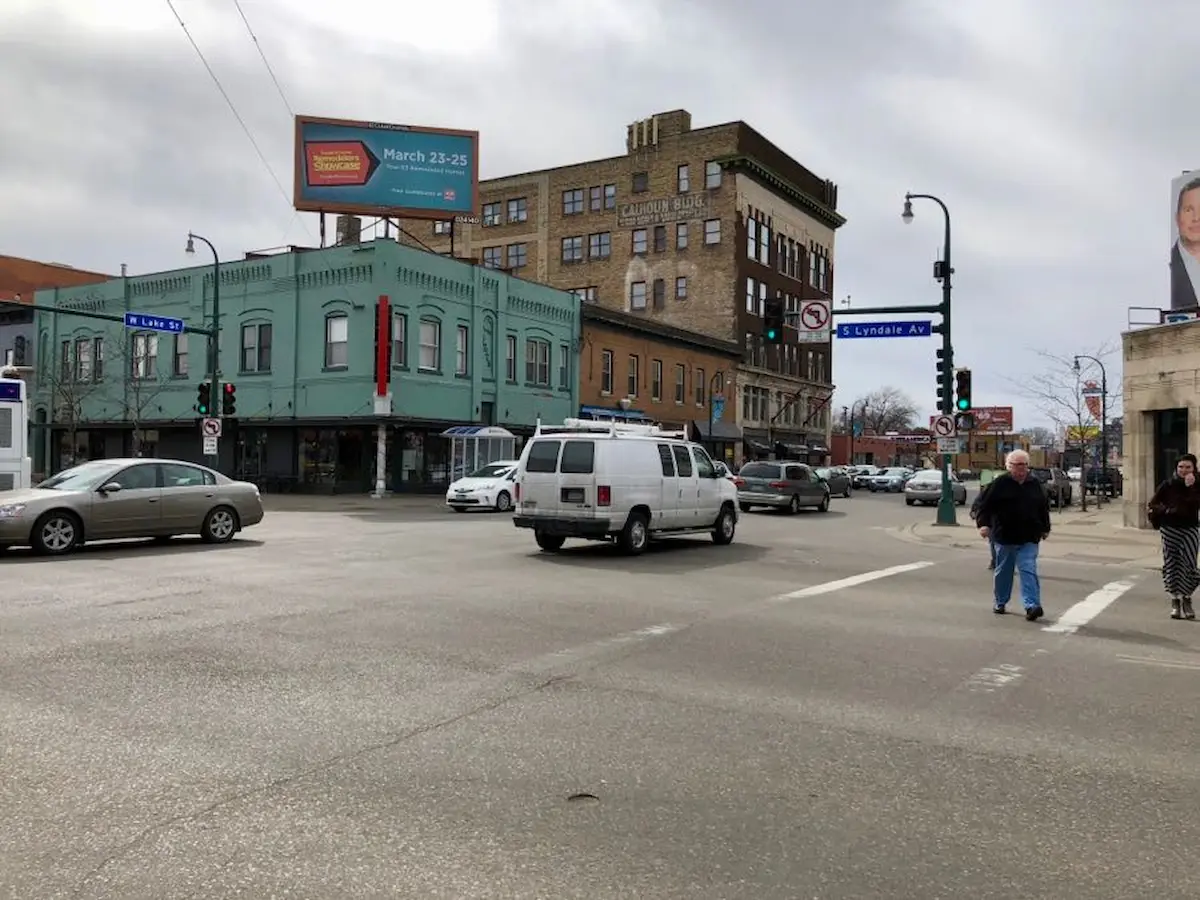
Hennepin County shared updated design concepts for the future of Lyndale Avenue S between Franklin and 31st Street. The three concepts, named “Blue, Purple, and Orange,” vary in their safety and accessibility for people walking, rolling, biking, and taking public transit.
Hennepin County has a new survey to collect feedback on the concepts to shape a finalized design, scheduled for Spring 2025.
While the proposed concepts make important strides in improving transportation access for people walking, rolling, biking, and taking public transit, all still fall short of best design practices for safety and car-free mobility. A major concern is Hennepin County’s decision to prioritize space for a few parking spots over speed and reliability for transit riders. Aside from a few short segments of bus lanes, Hennepin County’s options offer little for working-class people who take the bus on Lyndale.
This decision mirrors Mayor Frey’s veto of 24/7 bus lanes on the parallel Hennepin Avenue S reconstruction project, and will negatively impact transit riders who are disproportionately low-income and people of color.
Hennepin County can improve the Lyndale designs by:
- Including a protected bikeway for the entire length of the corridor
- Adding dedicated bus lanes on both sides of the street
- Adding a planted median along the entire project corridor
- Adding green space and preserving mature street trees
- Removing street parking and right turn lanes to create space for the above changes
Support Complete Streets in the Survey
Blue Option
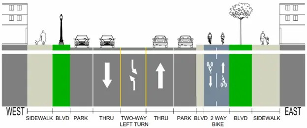
Pros:
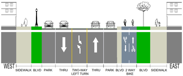
- Wide boulevard areas and sidewalks, and includes a two-way protected bike path north of 29th Street
- Fixes the bikeway gap between Franklin Avenue and the Loring Greenway bridge, connecting what is currently a dangerous place to ride alongside freeway-bound traffic
Cons:
- No dedicated lanes for transit. Car traffic regularly clogs Lyndale Avenue S during peak commute times, and red bus-only lanes are a proven strategy to make the bus fast and reliable. Lyndale Avenue S is also among the future planned bus rapid transit (BRT) routes making bus lanes on this corridor even more necessary.
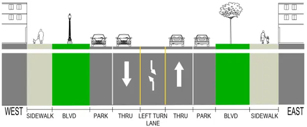
- Hennepin County included car parking on both sides of the street. Parking should be replaced with a bus lane and extended bikeway to 31st Street.
- Does not include a center median north of 24th Street, which prevents speeding and illegal passing while also providing a refuge spot for pedestrians.
- The blue option adds excessive right-turning lanes at the Lake Street intersection. Right-turn lanes widen crossing distances and increase potential conflicts with pedestrians. Hennepin County should use the space occupied by right turn lanes to add a bikeway and bus lanes near Lake Street, where they are most needed.
Purple Option

Pros:
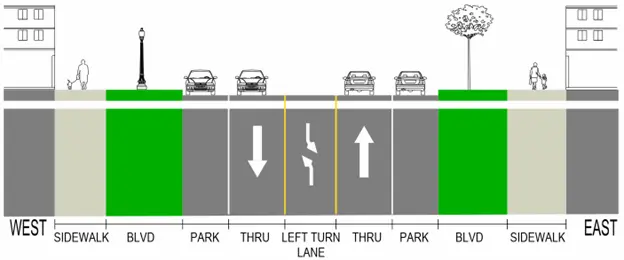
- Features relatively wide boulevard areas and sidewalks
- Fixes the bikeway gap between Franklin Avenue and the Loring Greenway bridge
Cons:
- While the purple option does add a segment of bus-only lane, the transit lane only runs in one direction and ends south of 24th Street. This neglects the most congested segment of Lyndale, near Lake Street, and means that thousands of transit riders will be subjected to slow and unreliable transit times. Bus-only lanes should encompass the entire corridor and should serve buses in both directions.
- The purple line features no protected bikeway, which will force people biking to choose between riding in traffic or on the sidewalk. Neither are safe or accessible for people of all ages and abilities. Study after study shows that protected bike lanes are good for business. Parking lanes should be replaced with a bikeway that encompasses the entire corridor.
- As with the other options, it is concerning that the purple option does not include a center median north of 24th Street, which prevents speeding and illegal passing while also providing a refuge spot for pedestrians. Center medians are also an opportunity to add street trees and greening, which can be seen on Lyndale south of 31st Street. Hennepin County should add a center median to all proposed designs for the entirety of the corridor.
- Like the other options, the purple option adds excessive right-turning lanes at the Lake Street intersection. Hennepin County should use the space occupied by right turn lanes to add a bikeway and bus lanes near Lake Street, where they are most needed.
Orange Option

Pros:
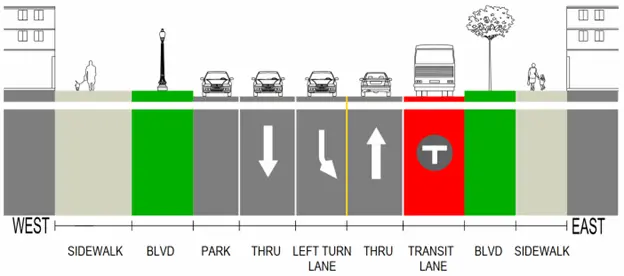
- Includes a two-way bikeway; although the bikeway ends south of 29th Street
- Fixes the bikeway gap between Franklin Avenue and the Loring Greenway bridge
- Includes a bus-only lane, but only for a small portion of the project area north of 24th Street
Cons:
- While the orange option does add a segment of bus-only lane, the transit lane only runs in one direction and ends south of 24th Street. Bus-only lanes should encompass the entire corridor and should serve buses in both directions.
- The protected bikeway in the orange option ends at 29th Street instead of continuing to 31st Street, providing safe access by bicycle to the many businesses in that segment of Lyndale. Parking lanes should be replaced with a bikeway that encompasses the entire corridor.
- It is concerning that the orange option does not include a center median north of 24th Street. Hennepin County should add a center median to all proposed designs for the entirety of the corridor.
- The orange option prioritizes parking over street trees. The parking lane and right turn lanes will result in many of the mature trees on Lyndale being cut down. Hennepin County should use the space occupied by parking and right turn lanes to save the maximum amount of existing mature trees.
Contact Project Decision-Makers
Josh Potter
Project Engineer
[email protected]
Marion Greene
Hennepin County Commissioner
[email protected]