Hennepin County is now planning the future of Lyndale Avenue S between Franklin Avenue and 31st Street. Here is what you need to know about the project and the ways that you can take action to make Lyndale a street for people.
Lessons from the 4:3 conversion
In 2021, community members successfully organized to convert this segment of Lyndale Avenue S from 4 lanes to 3 lanes (commonly referred to as a “4:3 conversion”, as well as add pedestrian medians at the 25th Street and 27th Street intersections. Lyndale Avenue has long had one of the highest crash rates in the City of Minneapolis and residents have called on the County to make design changes for decades. At the time, Hennepin County traffic engineers resisted substantial changes, arguing that a 4:3 conversion was impractical on Lyndale because there was too much traffic to accommodate. Community pressure forced the County’s hand, and a 4:3 pilot project was implemented.
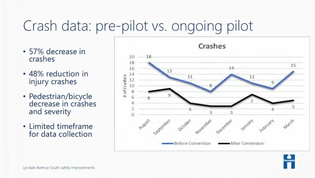
The project proved to be an overwhelming success. Data collected by Hennepin County clearly demonstrates that the project significantly improved safety for all street users, especially people walking and rolling. Total crashes were reduced by 57%. Traffic impacts were minimal, and 11% of the traffic at Lyndale & Franklin disappeared. Most drivers are now traveling within the speed limit. 83% of the County’s survey respondents said they felt safer walking or rolling across Lyndale.

This is yet another example of how traffic models should not be trusted as the final say on whether or not a project should move forward. It is a much better bet to trust the lived experience of residents and data from completed projects. It is also critically important context as we decide the future of Lyndale Avenue S for the next few decades. We get the transportation outcomes we design for, and the Lyndale Avenue S reconstruction project is an opportunity to design where walking, biking, rolling and public transit are convenient and comfortable for people of all ages and abilities.

Project Information and Timeline
Imagine a Lyndale Avenue South with wide sidewalks, an off-street bikeway, abundant trees and green space, fast bus service in dedicated lanes, public art, and more. This project is the opportunity to make it a reality.
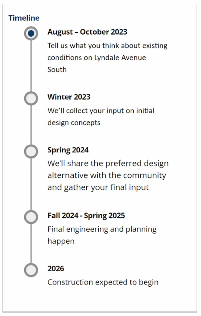
Hennepin County is now collecting feedback on community priorities and will reveal initial design options this winter. A final design will be selected in Spring 2024, with construction starting in 2026.
Take Action
Here is how you can take action to support a people-centered design on Lyndale.
- Attend an upcoming project open house Hennepin County is hosting on Thursday, August 24 from 4 – 6PM at Jungle Theater.
- Take the County’s online survey to share your priorities.
The survey is fairly short and includes 4 questions about your priorities for the project.
The first question asks whether or not you support the recent 4:3 lane conversion and pedestrian improvements. The second and third questions list potential street features, like protected bike lanes and dedicated bus lanes, and ask you to select the three that you view as most important and three that you view as least important.
Finally, the County included an open-response question that asks for additional comments.
Here are some suggested talking points to include:
- The new Lyndale should prioritize people over cards and include wider sidewalks, protected bike lanes, and 24/7 bus lanes
- The project area should be extended north to fix the sidewalk & bikeway gap between Franklin Avenue and the Loring Greenway so it is accessible for people of all ages and abilities
- The project should preserve existing mature trees wherever possible
- Hennepin County should work with the City of Minneapolis to include raised crosswalks on side streets
- The project should improve pedestrian lighting and incorporate public art
For questions about the project, you can contact the project manager Josh Porter at josh.potter@hennepin.us or 612-596-0820.